Film 1 · Colorado · September 20, 2026
The Real Reason Colorado’s Population Is Trapped in One Place
The short version
Four out of five Coloradans live on one narrow strip at the foot of the Rockies. It isn't because of the mountains. Here's what actually put them there: geology, broken treaties, a gold rush, the railroad that skipped Colorado, water moved under the Continental Divide, and Uncle Sam.
Key ideas
What you need to know
The ideas the film's argument rests on, explained plainly, with the moment in the film that shows each one.
Mile-high plains to 14,000-ft peaks 1 of 6
The mountain front and its canyon mouths
The Front Range rises almost straight off the plains, from a mile above sea level to peaks over 14,000 feet within a few miles. About 70 million years ago, in the Laramide orogeny, the crust here was squeezed from the west. The range was pushed up while the land east of it sagged into the Denver Basin, which filled with rubble washed off the rising mountains. The edge is sharp and geologically quiet. Every few miles a river leaves its canyon for the plains, from the Cache la Poudre at Fort Collins to the Arkansas at Pueblo. Towns grew at those mouths, serving the mountains without being trapped in canyons that rockfall and floods could close.
Watch this part · 2:04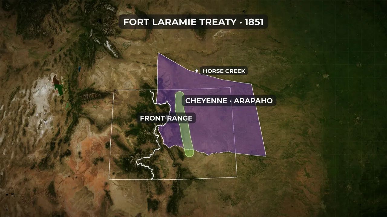
Fort Wise, 1861: one-thirteenth left 2 of 6
Whose land the Front Range was
The Ute, who call themselves Nuche, held the mountains. An 1851 treaty recognized Cheyenne and Arapaho territory from the Continental Divide across the plains, Front Range included. After gold drew tens of thousands onto that land, a few of their leaders were pressured at Fort Wise in 1861 to accept about one-thirteenth of it. In 1864 Colorado volunteers attacked Black Kettle's camp at Sand Creek, whose people had been told they were under the army's protection. The National Park Service counts more than 230 dead, well over half of them women and children. By 1881 the Cheyenne and Arapaho had been driven from Colorado and the White River and Uncompahgre Utes marched to Utah. Their nations are still here today.
Watch this part · 5:55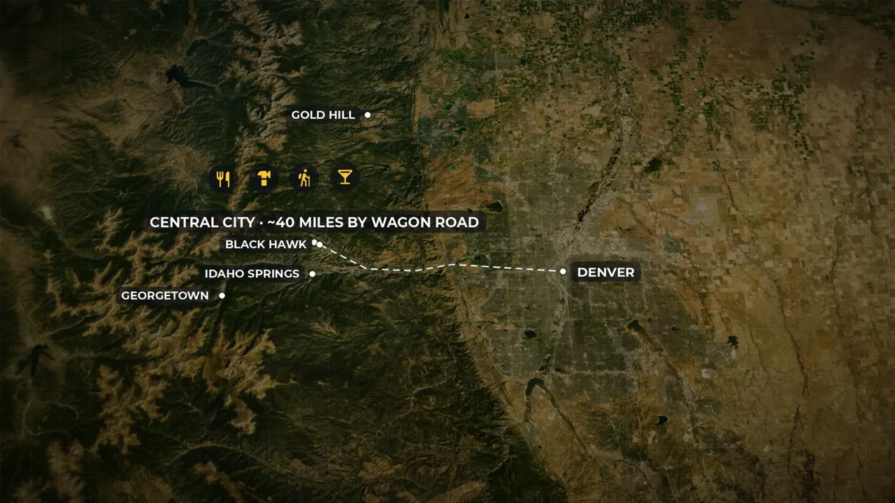
80,000 set out, 34,000 counted 3 of 6
Denver grew by supplying the gold camps
Something like 80,000 people set out for the “Pikes Peak” gold fields in 1859, though the first find was small and seventy miles from Pikes Peak. The census the following year counted just 34,000 people in the whole territory. The others went home as “go-backers.” A rush can bring people overnight, but it cannot make them stay. What kept Denver going was supply. The richer strikes were forty miles up in the mountains, and the miners there needed food, tools, lumber and someone to buy their ore. The town at the canyon mouths became their depot, and later their smelter. Farmers followed, digging ditches from the first summer, since it rains only about fifteen inches a year here.
Watch this part · 11:53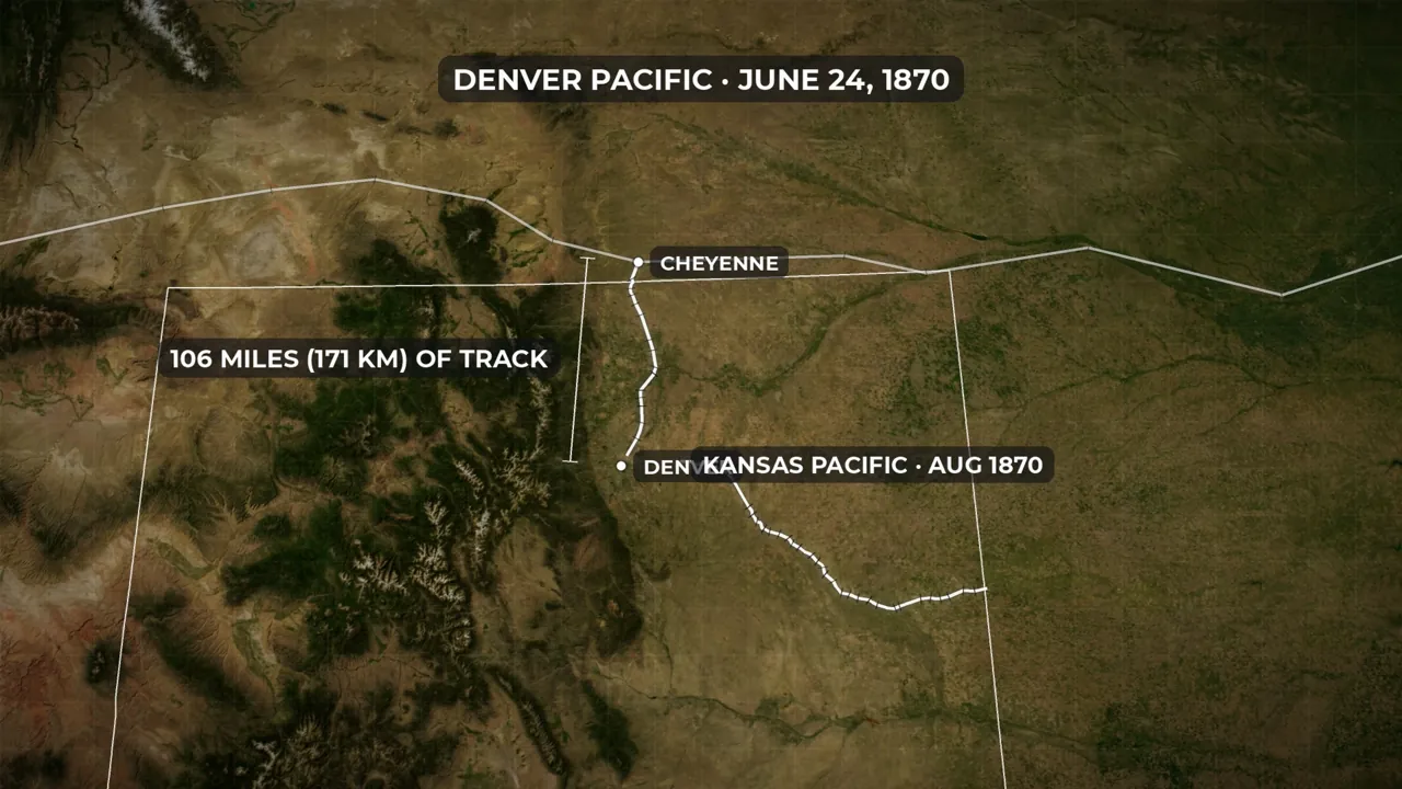
106 miles of track to Cheyenne 4 of 6
Railroads strung the towns together
In 1867 the Union Pacific, the first transcontinental railroad, avoided the mountain wall west of Denver and ran through Wyoming, where the Rockies are lower. Cheyenne got the line, and people began leaving Denver. Former territorial governor John Evans built the Denver Pacific 106 miles north to meet it; the first train reached Denver on June 24, 1870. Every line leaving Denver then spawned towns. Greeley, Longmont and Colorado Springs followed one pattern: land, railroad and a story, sold as a package to people who had never seen the place. By 1880 nearly every new town sat on a rail line along the foot of the mountains, the chain Interstate 25 follows today.
Watch this part · 15:34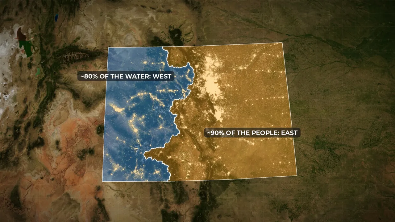
80% water west, 90% people east 5 of 6
Bringing water under the Continental Divide
About 80 percent of Colorado's water falls west of the Continental Divide; about 90 percent of its people live east of it. Compacts with downstream states require roughly two-thirds of the state's river flow to leave. Law came first: prior appropriation, first in time, first in right, let the earliest user carry river water as far as they liked, and by 1900 the South Platte was fully spoken for. Then came engineering. The Colorado-Big Thompson Project, begun in 1938, pumps Colorado River headwaters into Grand Lake and through a 13-mile tunnel, 3,800 feet under the Divide, to the northern Front Range. The farms and towns came first, then used their money and political weight to bring the water to them.
Watch this part · 24:18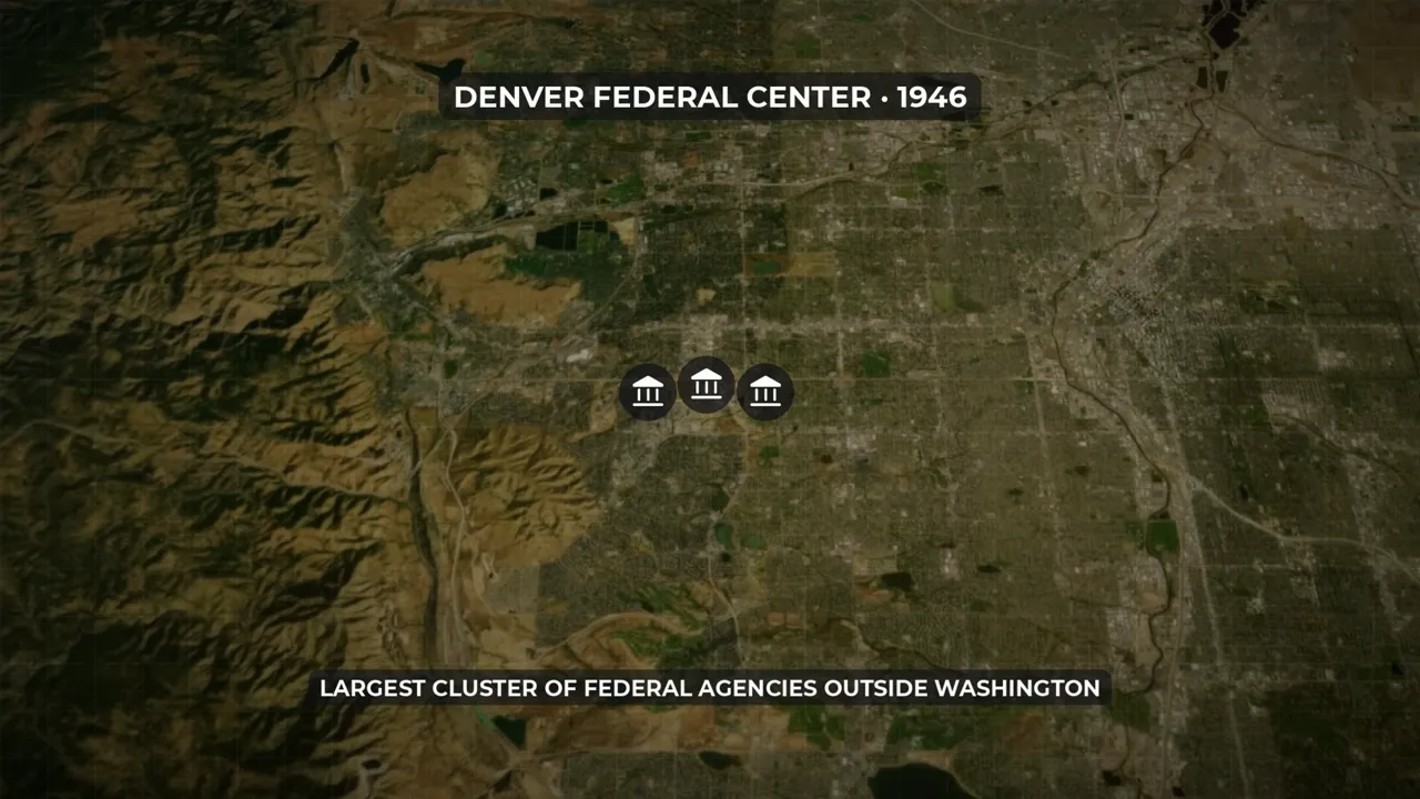
Ordnance plant became Federal Center, 1946 6 of 6
The federal government moved in and stayed
In January 1941 the federal government contracted for an ammunition plant on farmland west of Denver. Two years later it employed almost 20,000 people. Air fields, an army hospital, the Rocky Mountain Arsenal and Camp Carson followed. After the war the plant did not close: it became the Denver Federal Center in 1946, and Camp Carson became Fort Carson. The Cold War added the Air Force Academy, NORAD inside Cheyenne Mountain, and the Titan missile plant near Denver. Soldiers rotate out, but civilian staff, contractors, teachers and retired officers stay, so each layer made the next one cheaper to add. Interstate 25, finished in 1969, linked cities that already existed, and the scenery only began tipping people's choices after 1990.
Watch this part · 28:01
Explore
The map from the film
Turn the film's layers on and off, switch to satellite, and click anything for what it is.
Names
How locals say them
Two names the narration got wrong, as viewers told us. If you heard another, tell us below.
| Name | How locals say it | Note |
|---|---|---|
| Cache la Poudre | cash-la-POO-der (locals just say POO-der) | Viewer correction. The film said "powder". |
| Los Angeles | loss AN-juh-lus | Viewer correction. The film said "Lowe's Angels". |
Transcript
Read the film
The full narration, chapter by chapter. Click a time to play from there.
01Why 4 in 5 Coloradans live on one strip0:00
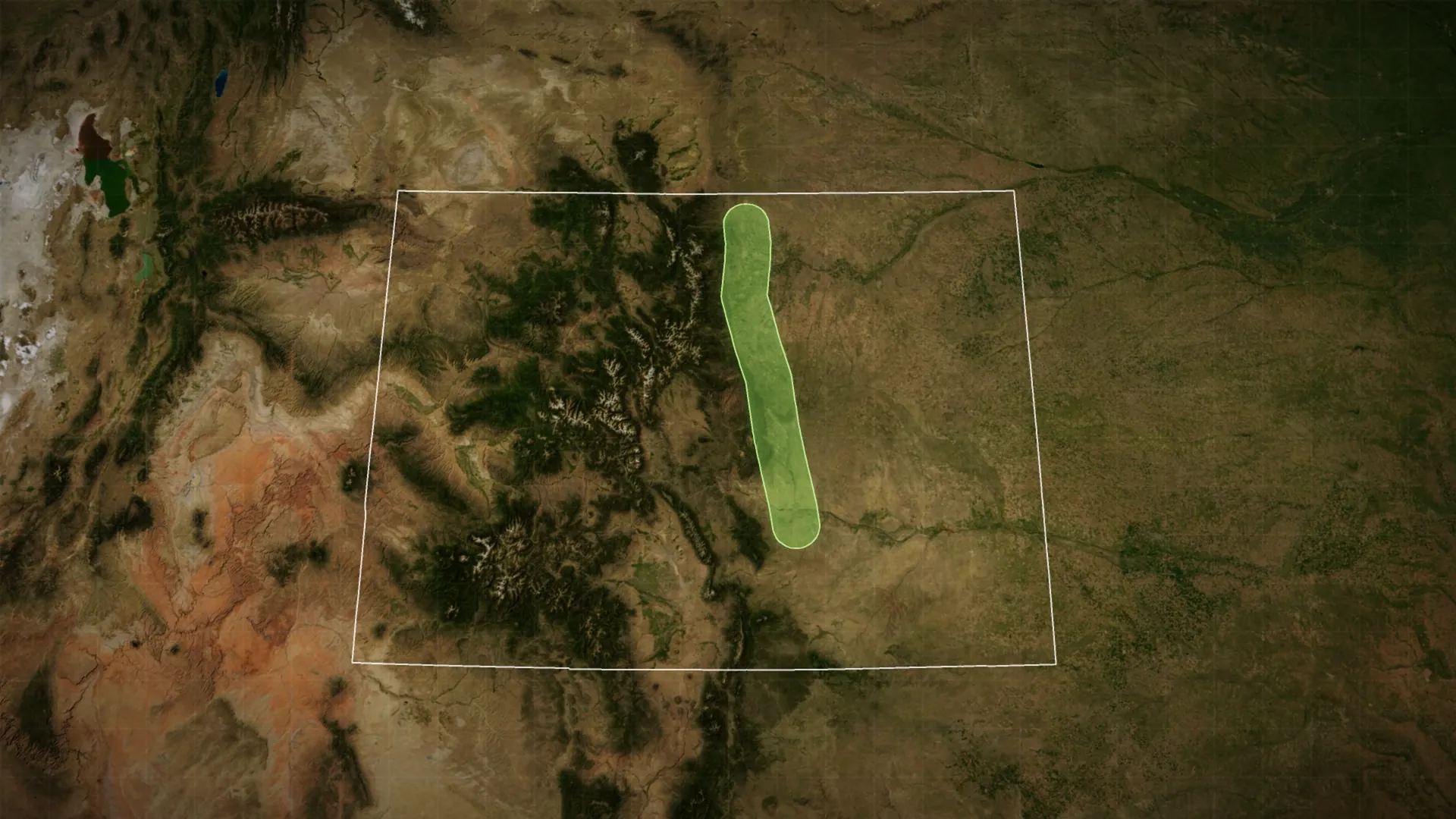
0:00Welcome to Colorado. A hundred and four thousand square miles of it, which makes this one state bigger than the entire United Kingdom. It has more peaks over fourteen thousand feet than any other state, and rivers that start here end up supplying water to nineteen states and Mexico. And yet, if you look at Colorado at night, almost all of it is dark. Nearly every light in the state sits in one thin band pressed against the eastern face of the Rocky Mountains, running about a hundred and eighty miles from Fort Collins in the north, down through Boulder and Denver, past Colorado Springs, to Pueblo in the south. Locals call it the Front Range.
0:47More than four in five Coloradans, about five million people, live in the eleven counties that make up this strip. Everything else, the mountains, the western plateaus, the entire eastern third of the state, shares what is left over. Now, the easy answer is that people like living next to mountains. But that explanation falls apart the moment you look closely at the map. This bright strip sits on the dry side of the Continental Divide, where only about a fifth of the state's water actually falls.
1:23Its cities were founded decades before the interstate that seems to string them together. And the land underneath them was never empty. So why, in a state with this much room, do Coloradans crowd onto one narrow ledge between the mountains and the plains? Today we're going to find out. The story runs from an ancient collision deep in the Earth's crust, through a gold rush built on a lie, a massacre, a railroad that skipped the state entirely, a tunnel drilled thirteen miles under the mountains, and a fortress built inside one of them.
2:02Let's get into it.
02The wall2:04
2:04Drive west across the Great Plains toward Denver and for four hundred miles nothing much happens. Then a faint blue line appears on the horizon, and an hour later it has become a wall. Unlike most mountain ranges, which ramp up gradually, the Front Range rises almost straight out of the flat ground, from a mile above sea level to peaks over fourteen thousand feet in the space of a few miles. That sharp edge is the whole story, so it's worth knowing where it came from. Around seventy million years ago, during a mountain-building event geologists call the Laramide orogeny, the crust here was squeezed from the west.
2:48The Front Range was shoved upward, and at the same time the land just east of it sagged into a deep trough called the Denver Basin. As the mountains rose, rain and rivers tore them apart and dumped the rubble into the basin, building a broad, gently sloping apron of sediment that the mountains now sit on like a bookend on a shelf. The rock in those mountains is over a billion years old, but the range itself is young and, unlike California, geologically quiet. You can build a city against this wall without worrying that it will move.
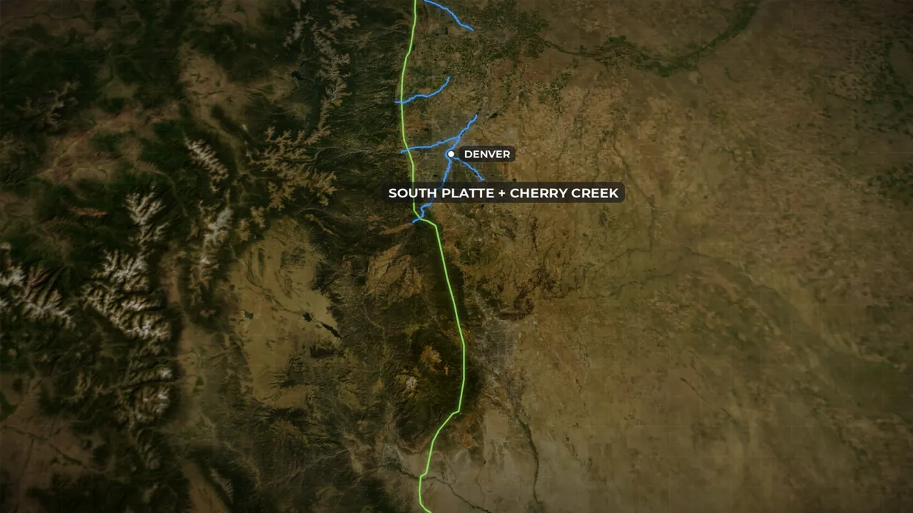
3:26And here's what that edge gives you. On the west side: headwaters, timber, minerals, and canyons that lead into the high country. On the east side: flat, buildable, farmable land. And right along the seam, every few miles, a river comes bursting out of a canyon onto the plains. The Cache la Poudre at Fort Collins. Boulder Creek at Boulder. Clear Creek at Golden. The South Platte and Cherry Creek at Denver. Fountain Creek at Colorado Springs. The Arkansas at Pueblo. That first river, by the way, got its name when a party of French trappers were caught by an early snowstorm sometime in the 1820s and buried their gunpowder on the riverbank to keep it dry. Cache la Poudre.
4:19Hide the powder. Nobody is entirely sure whether they ever came back for it. Every one of those canyon mouths is a natural meeting point between two worlds. You can reach the mountains from there, but you don't have to live in them. Clear Creek Canyon, the route into the richest early gold fields, is so narrow that a road and a river barely fit side by side, and it was regularly closed by rockfall and floods. So the sensible thing was to build at the mouth, where you could serve the mountains without being trapped inside them.
4:57But before you picture this as some kind of natural paradise, understand what the edge does not give you. Rain. Denver gets about fifteen inches a year, roughly the same as Tucson. Chinook winds roar down off the peaks and can raise the temperature forty degrees in an hour. Hail here regularly does billions of dollars of damage. And the same canyons that make such convenient front doors also funnel flash floods straight into town. In 1976 the Big Thompson flood killed a hundred and forty-four people in a single evening.
5:38So geography handed the Front Range a useful edge and a lot of ways to die on it. It did not hand anyone a city. To understand how five million people ended up here, we have to look at who was here first, and what happened to them.
03Whose land was it?5:55
5:55People have been living along this mountain edge for at least ten thousand years. By around the year fifteen hundred, the Ute, who call themselves Nuche, held the mountains and came down to the edge with the seasons. The Cheyenne and Arapaho arrived on the plains around eighteen hundred, pushed west from the Great Lakes by earlier waves of displacement. Comanche, Kiowa, Apache, and Lakota people all used this country too. The canyon mouths were valuable to them for exactly the reasons they would later be valuable to everyone else: water, shelter, game, and a route between the plains and the high country.
6:37In 1851, at Horse Creek near Fort Laramie, the United States signed a treaty recognizing Cheyenne and Arapaho territory stretching from the Continental Divide out across the plains, the entire Front Range included. That treaty was never ratified, and nobody in Washington paid it much attention. Then, seven years later, somebody found gold. We'll get to the gold rush in a moment, because it deserves its own chapter. What matters here is what it did to the map. Tens of thousands of people poured onto land that, on paper, belonged to someone else. And within three years, in February of 1861, a small group of Cheyenne and Arapaho leaders were pressured into signing a new treaty at Fort Wise that shrank their territory to about one-thirteenth of what the old one had recognized. One of the signers was a Southern Cheyenne peace chief named Black Kettle, who objected as he signed that Cheyenne law required the consent of leaders who weren't in the room. Most of the bands never accepted the deal.
7:51What followed is the darkest chapter in Colorado's history. On the morning of November 29, 1864, about six hundred and seventy-five Colorado volunteers attacked Black Kettle's village on Sand Creek, a camp of around seven hundred and fifty people who had been told they were under the army's protection. Black Kettle raised an American flag and a white flag over his lodge. The soldiers attacked anyway. The National Park Service puts the dead at more than two hundred and thirty, well over half of them women and children.
8:29It was not a battle. It was a massacre, and Congress said so within a year. Black Kettle survived Sand Creek. Four years later he and his wife were killed when the Seventh Cavalry attacked another Cheyenne village on the Washita River in Oklahoma. By then the Cheyenne and Arapaho had been driven out of Colorado entirely, and the plains side of the Front Range was open for farms, towns, and railroads. The mountain side took a little longer. The Ute held a huge reservation covering most of western Colorado into the 1870s. Then silver was found in the San Juans, and in 1873 an agreement stripped away nearly four million acres.
9:19Six years after that, a federal agent named Nathan Meeker, whom you'll meet again shortly in a very different role, tried to force the White River Utes to give up their horses and take up farming, and plowed up their racetrack to make the point. When he called in troops, fighting broke out, Meeker and his staff were killed, and Colorado's newspapers had the excuse they'd been waiting for. In 1881 the Utes of the White River and Uncompahgre valleys were marched out of the state to Utah.
9:53The Southern Ute Tribe's own history puts it in one line: “ There is no migration story, we were placed here in the mountains. ” So keep that in mind for the rest of this video. When we talk about people moving to the Front Range, we're talking about settlers. The people already here didn't migrate. They were removed. And they are still here today, as the Southern Ute, the Ute Mountain Ute, and the Cheyenne and Arapaho nations, with their own governments and their own claims on this history.
10:27Now, back to the gold.
04Pikes Peak or bust10:30
10:30The Colorado gold rush is a strange one, because the gold that started it was, frankly, not very good. In June of 1858, a party of about a hundred prospectors led by a Georgia miner named William Green Russell, and including a number of Cherokee men who'd heard rumors about the region for years, reached the spot where Cherry Creek meets the South Platte. Most of them looked around, panned a few creeks, found next to nothing, and went home. Thirteen stayed. And in July those thirteen found a few hundred dollars' worth of gold in a gulch called Little Dry Creek.
11:12That should have been the end of it. Instead, on August 26, the Kansas City Journal of Commerce ran the story, and it spread east like wildfire. Through the winter, guidebooks appeared in every town along the Missouri River promising easy fortunes in the “ Pikes Peak ” gold fields. Never mind that Pikes Peak was seventy miles from where the gold had actually been found. It was the only landmark in Colorado anyone back east had heard of, so that's what they called it, and people painted “ Pikes Peak or Bust ” on their wagon covers and set off across the plains.
11:53The country had just been through the Panic of 1857, farms were failing, and for a young man in a crowded eastern town a rumor of gold was all the excuse he needed. Something like eighty thousand people set out for Colorado in 1859. Here's the thing, though. When the census came through the following year, it counted just thirty-four thousand people in the whole territory. So where did the other forty-five thousand go? They went home. Colorado had a word for them: go-backers.
12:31Thousands of people arrived at Cherry Creek, found that the placers were thin, that the winters were brutal, and that the good strikes were up in the mountains in places like Central City that were miserable to reach and worse to live in, and they turned around. The wagons heading back east had a new slogan painted over the old one. “ Busted, by gosh. ” And this is the pattern you'll see over and over for the next hundred and fifty years. A rush can get people to Colorado overnight.
13:04It can't get them to stay. Something else has to do that. So what kept the thirty-four thousand? Mostly, it wasn't gold. The richer strikes of 1859 were forty miles up in the mountains, and the miners up there needed everything: food, tools, boots, whiskey, lumber, and somebody to buy their ore. The little town at the mouth of the canyons became the supply depot for all of it. Denver didn't get rich digging gold. It got rich selling shovels to the people who did, and later smelting what they brought down. By the 1890s the smelters were among the biggest employers in the city.
13:50Farmers followed, and since it rains about fifteen inches a year here, farming meant digging a ditch from the very first summer. Then came the institutions that make a place stick. Congress created Colorado Territory in 1861, the Homestead Act arrived a year later, opening up land that had just been taken from the Cheyenne and Arapaho, and statehood came on August 1, 1876, exactly a hundred years after the Declaration of Independence. Which is why Colorado calls itself the Centennial State.
14:27If you want to see how a rush turns into a town, look at Clara Brown. She was a formerly enslaved woman in her late fifties when she came west in 1859, not to dig for gold but to wash clothes for the people who did. She earned her way across the plains as a cook on a wagon train, set up a laundry in the mining camps, and in a place where nobody else was doing laundry, that turned out to be a very good business. She put the money into property, spent decades searching for the family that slavery had scattered, found her daughter in Iowa in 1882, and paid for other freed people to come west and get started.
15:11She never touched a gold pan, and she's exactly why Denver survived when the placers ran out. Services, families, and people helping each other are what turn a camp into a city. But a handful of towns doesn't make a corridor. For that, somebody had to connect them. And the first attempt went very badly.
05The railroad that skipped Colorado15:34
15:34In 1867 the Union Pacific was building the first transcontinental railroad west across the plains, and Denver assumed it would come through town. It didn't. The surveyors took one look at the wall of mountains west of Denver and routed the line north through Wyoming instead, where the Rockies are lower and there's a gap. Cheyenne got the railroad. Denver got nothing, and people started leaving. So what saved it? A former territorial governor named John Evans did what any sensible city does when the railroad skips you: he built his own.
16:15The Denver Pacific ran a hundred and six miles north to meet the Union Pacific at Cheyenne, and the first train rolled into Denver on June 24, 1870. Two months later the Kansas Pacific arrived from the east. Almost overnight Denver went from a bypassed mining camp to the hub of a spiderweb of rail lines reaching into every corner of the Rockies. And that spiderweb is what built the Front Range, because every line that left Denver, north or south, spawned towns along the way. Take Greeley. In December 1869, before the Denver Pacific was even finished, the agricultural editor of the New York Tribune, a man named Nathan Meeker, wrote an article calling for people to join him in founding a farming colony in Colorado. Hundreds of letters came back.
17:13In the spring of 1870 his Union Colony laid out a town right beside the new tracks, between the Cache la Poudre and the South Platte, and dug twenty-seven miles of irrigation canal in its first year. Greeley banned alcohol, planted trees, and sold itself to respectable eastern families as a temperance utopia with a train station. That's the same Nathan Meeker who, nine years later, got himself appointed Indian agent for the White River Utes and tried to run their reservation the way he'd run Greeley. It ended with him dead and the Utes deported.
17:53The same confidence, applied first to volunteers and then to people who had no choice. Greeley wasn't a one-off. A colony from Chicago bought sixty thousand acres from the railroad's land company and founded Longmont in 1871. Fort Collins got a colony and a rail line of its own. Boulder, a supply camp for the gold fields up Boulder Canyon, landed the state university in 1877 by donating the land to get it. And then there's Colorado Springs, which might be the most nakedly manufactured city in America.
18:35William Jackson Palmer was a Civil War general who came out to Colorado with the Kansas Pacific and decided that the real money was in a railroad running south from Denver toward Mexico. He incorporated the Denver and Rio Grande in October 1870. The problem with a railroad through empty country is that nobody rides it. So Palmer solved that problem by building the customers. On July 31, 1871, his colony company drove the first survey stake into the ground at the foot of Pikes Peak.
19:13The next morning they were selling lots. And on October 27, less than three months after that stake went in, the first passenger train from Denver pulled into a town that hadn't existed in the summer, seventy-five miles in about five hours. Palmer marketed the place to wealthy easterners and British invalids as a health resort with dry air and mountain views, and banned saloons, which is why the rowdier old settlement next door did such good business. For a while there were so many English residents that people called it Little London.
19:51The pattern was set in 1871: land, railroad, and a story, sold as a package to people who had never seen the place. Pueblo, at the south end of the strip, went the other way. Where the Arkansas River comes out of the mountains, Palmer's railroad met coal from the south and iron ore from the west, and by the 1880s Pueblo had the biggest steel mill west of the Mississippi. The Colorado Fuel and Iron Company employed thousands, drew workers from Italy, Slovenia, Mexico, and forty other places, and turned Pueblo into the state's blue-collar capital.
20:33So look at the map by 1880. In one decade Colorado's population had gone from under forty thousand to nearly two hundred thousand, and nearly every new town sat on a rail line hugging the base of the mountains. The chain that Interstate 25 follows today was already there. It was made of steel rails, irrigation ditches, and real-estate prospectuses, and it was built on purpose.
06Who did the work21:02
21:02Of course, a railroad, a smelter, and a sugar-beet field don't run themselves, and the towns needed far more people than Palmer's brochures were ever going to attract. By 1870, one Coloradan in six had been born outside the United States. Irish crews built the Union Pacific. Italians laid the later lines and dug the coal. Germans ran the breweries, including a small one in Golden started in 1873 by a man named Adolph Coors. Swedes, Poles, and Russian Jews were recruited by Denver employers through the 1880s and 90s.
21:45There was also a movement north that wasn't immigration at all. Hispano families had been farming the San Luis Valley in southern Colorado since the 1840s, when it was still Mexico, and the border moved across them in 1848 without anyone asking. When the railroads reached the valley and changed who controlled the land, the poorer families moved north for wages in the mines, the Pueblo mill, and, above all, the beet fields. The northern Front Range grew sugar beets on an enormous scale in the early twentieth century, and beets need hand labor for weeks at a time.
22:26Great Western Sugar recruited Hispano, Mexican, Japanese, and German-Russian families by the trainload and built labor colonies to house them. The photographer Lewis Hine visited one family in 1915: three adults and six children, the youngest seven years old, working fourteen-hour days. A few of those families eventually bought farms of their own. For most, it was low pay, bad housing, and, during the Depression, the constant threat of deportation. And in Denver, Black railroad workers, many from Georgia, built a neighborhood next to the rail yards. Pullman porters and dining-car waiters had some of the steadiest jobs a Black man could get in the 1880s, and their families put down roots in Five Points. Restrictive housing covenants meant they couldn't live anywhere else, so by 1929 three-quarters of Black Denver lived in one neighborhood, which then produced its own banks, newspapers, churches, and one of the best jazz scenes between Kansas City and Los Angeles.
23:38A community, and a cage, at the same time. Put it all together and by 1900 the Front Range was a machine that fed itself. Mines needed food and machinery, farms needed workers and customers, smelters needed ore and coal, and the railroads carried all of it, bringing a few more people with every trip. When a mine failed, and they always did eventually, the town around it had a courthouse, a school, and a bank, and it kept going. But the machine was about to hit a wall of its own.
24:14It had been built on the wrong side of the water.
07The wrong side of the Divide24:18
24:18Here's Colorado's fundamental problem in one sentence. About eighty percent of the state's water falls on the west side of the Continental Divide, and about ninety percent of its people live on the east side. And most of that water isn't even Colorado's to keep. Under the compacts it signed with its downstream neighbors a century ago, roughly two-thirds of the state's river flow has to be allowed to leave. What's left mostly runs west toward Utah, away from the farms and cities we've been watching grow.
24:56The first answer to this was law. Colorado invented a rule called prior appropriation, first in time, first in right, which let anyone dig a ditch, take water out of a river, and carry it as far as they liked, so long as they'd been there first. By 1900 the state had more irrigated land than any other in the country. It also had a South Platte River that was, legally, completely spoken for. Then the 1930s arrived. Drought, dust storms, and grasshoppers wiped out the eastern plains. History Colorado estimates a tenth of the state's topsoil simply blew away that decade. Farmers abandoned their land, and Colorado's population, which had been doubling every generation, grew by only eight percent in ten years. A Black farming colony called Dearfield, out east of Greeley, emptied out completely.
25:57But notice where those farmers went. Most of them didn't leave Colorado. They moved into the Front Range towns, where New Deal programs were building schools, parks, roads, and airports and paying people to do it. Government work became the reason to stay. Remember that, because the next chapter is built entirely on it. So how do you get water to a few million people on the wrong side of a mountain range? Out of the same Depression came the answer, and it's the biggest engineering project the corridor has ever seen.
26:36The Colorado-Big Thompson Project, begun in 1938, takes water from the headwaters of the Colorado River on the west side, pumps it up into Grand Lake, and sends it through a tunnel thirteen miles long, bored thirty-eight hundred feet below the Continental Divide, straight under Rocky Mountain National Park. It comes out on the east side above Estes Park and drops through a chain of power plants and reservoirs to the farms and cities of the northern Front Range. In an average year it moves about two hundred and thirty thousand acre-feet, through more than a hundred dams, tunnels, canals, and pumping plants strung across the mountains. The Bureau of Reclamation's own history says, in so many words, that this project laid the foundation for the subdivisions that later covered northern Colorado.
27:32The important point is which way the water moved. It moved toward the people, not the other way around. Once enough farms and towns had piled up on the dry side of the mountains, they had the money and the political muscle to bring the water to them. Population came first. The water followed. Rail and water made the Front Range possible. What made it enormous was Uncle Sam.
08Uncle Sam moves in28:01
28:01On January 4, 1941, eleven months before Pearl Harbor, the federal government signed a contract to build an ammunition plant on farmland west of Denver. Two years later the Denver Ordnance Plant employed almost twenty thousand people, working three shifts around the clock, turning out over six million rifle cartridges a day. Half of them were women. And that was one plant. Lowry and Buckley air fields went up east of Denver, Fitzsimons became one of the biggest army hospitals in the country, and the Rocky Mountain Arsenal started making chemical weapons on the prairie northeast of town.
28:44Outside Colorado Springs the army carved Camp Carson out of sixty thousand acres of ranch land and ran more than a hundred thousand soldiers through it before the war ended. Denver's population jumped by nearly a third in the 1940s. Now here's the part that matters. When the war ended, the ammunition plant didn't close and scatter its workers. In 1946 it became the Denver Federal Center, still today the largest concentration of federal agencies anywhere outside Washington. Camp Carson became Fort Carson.
29:25A wartime emergency had left permanent institutions behind, and permanent institutions buy groceries, build houses, and send kids to school for decades. Then the Cold War arrived, and Colorado Springs won the lottery. In 1954 Congress put the new Air Force Academy on a huge tract north of the city. In 1957 the Air Force picked the city for NORAD, the command that watches the skies over North America for incoming missiles. And to make sure NORAD would survive the missiles it was watching for, the army spent four years hollowing out Cheyenne Mountain, just south of town, to build a command center two thousand feet inside the granite, behind two twenty-five-ton blast doors, on giant springs so the whole thing could ride out a nuclear blast.
30:22Between 1950 and 1964 the number of uniformed personnel around Colorado Springs went from under five thousand to over twenty-six thousand. Denver got the aerospace side. In 1955 the Glenn L. Martin Company announced a plant southwest of the city to build the Titan intercontinental ballistic missile, and engineers, suppliers, and federal labs clustered around it. Along with them came Rocky Flats, the plant northwest of Denver that made the plutonium triggers for the nation's nuclear weapons, and left behind a contamination problem the region is still cleaning up.
31:06You might think military postings are the opposite of permanence. A soldier is here for three years and gone. But a base needs civilian staff, construction crews, doctors, teachers, and contractors, and none of those rotate out. Retired officers settle near their last base. Defense firms follow the contracts. Colorado Springs tripled in size between 1950 and 1970, and every federal dollar changed what the next employer would find here. Runways. Laboratories. Engineers. Families. Each layer made the next one cheaper to add.
09Locked in31:50
31:50Which brings us, finally, to the road. Interstate 25 runs the full length of the Front Range and is the reason most people picture the corridor as one long city. Denver's stretch, the Valley Highway, opened in 1958, and the last of the state's two hundred and ninety-nine miles was finished in 1969. But you'll have noticed by now that the highway didn't create anything. Every city on it was already there. What the interstate changed was the scale of daily movement. When I - 25 opened through Colorado Springs, about eight thousand cars a day used the middle of it. By 2005 it was a hundred thousand.
32:37The highway plus the GI Bill plus cheap mortgages turned the corridor into one enormous suburb. Jefferson County, west of Denver, nearly quadrupled between 1940 and 1960. Lakewood, the town that grew up around the old ordnance plant, didn't even bother to incorporate until 1969, by which point it already had ninety thousand people. And access to all of this was not equal. Redlining and restrictive covenants kept Black, Latino, Asian, and Jewish families out of exactly the suburbs that were locking everyone else in.
33:17By 1970, eighty percent of Coloradans lived on the Front Range. Then the oil crisis hit, and Denver became the headquarters for every energy company drilling the Rockies, two thousand of them by 1979. The metro area grew by a third in a decade, and the growth was so fast and so unpopular that in 1972 Colorado voters did something no place had done before: they turned down the Winter Olympics after already being awarded them. When oil crashed in the 1980s, the energy companies left, and Colorado's growth rate fell by more than half. But the corridor didn't empty out, because by then it wasn't a one-industry town. It had the federal government, aerospace, big universities, and a growing tech sector, and each one carried people through the bust.
34:15And then, from 1990 onward, the mountains finally show up in the story. Sunshine, ski slopes, and three hundred days of good weather became the reason people picked Denver over Dallas or Phoenix. Colorado added two and a half million people in thirty years, most of them from California, Texas, and Mexico, and in the 2010s more than half of Denver's growth was people who'd moved there from somewhere else. But notice the order of events. The scenery was always there. What it did was tip the balance for people choosing between job markets that already existed.
34:56It never built one. Now, for the first time in twenty years, that lock-in is slipping. In 2025 Colorado actually lost people to other states. Housing along the Front Range has climbed out of reach for many of the people who work there, the water system is running at its limits, and wildfires keep burning into the suburbs. The strip that was built by making it easy to stay is starting to make it hard.
10To sum it all up35:27
35:27So, to sum it all up. Four in five Coloradans live on one narrow strip not because of the mountains, but because of a ledge at the foot of them that turned out to be useful over and over again. Geology made the edge. Dispossession opened it. Gold brought a crowd, and shopkeepers, farmers, and laundresses kept a piece of it. Railroads and land companies strung the towns together on purpose. Engineers hauled the water over the mountains to the people who'd already arrived. The federal government moved in during a war and never left.
36:06And the highway, the suburbs, and finally the scenery piled on top of all of it, each one making the next move easier than starting somewhere else. The lights on that night map aren't where Coloradans chose the best view. They're where a hundred and fifty years of decisions kept landing in the same place. Thanks for joining me today. If you enjoyed this one, there's a whole video coming on how Colorado moves water under the Continental Divide, and who pays for it. Subscribe so you don't miss it, and I'll see you next time on The Wayfaring Kind.
Your story
What did we miss?
The best things we have learned since publishing came from people who live there: family who worked the mills, the river everyone knows we forgot, the date we got wrong. Tell us yours.
Quiz
How well do you know Colorado?
A few questions the film answers. Nothing is recorded; it's just for fun.
1 of 6 · Guess the number
Out of every 10 Coloradans, how many live on the Front Range strip?
More than four in five Coloradans, about five million people, live in the eleven counties of the strip running from Fort Collins to Pueblo.
Watch this part · 0:472 of 6 · Say it like a local
Say it like a local: Cache la Poudre.
POO-der. Our narrator said “powder”, and a lot of you told us. The name means “hide the powder”: French trappers buried their gunpowder on the bank in the 1820s.
Watch this part · 3:263 of 6 · Tap the map
Western water comes east through a 13-mile tunnel under the Divide. Tap where you think it comes out.
It comes out on the east side above Estes Park and drops through a chain of power plants to the northern Front Range.
Watch this part · 26:364 of 6 · Question
In 1867, where did the Union Pacific route its line instead of through Denver?
Surveyors saw the mountain wall west of Denver and went north through Wyoming, where the Rockies are lower. Cheyenne got the railroad, so Denver built its own 106-mile line to reach it.
Watch this part · 15:345 of 6 · Guess the number
What share of Colorado's water falls west of the Continental Divide?
About 80 percent of the water falls west of the Divide, and about 90 percent of Coloradans live east of it. Hence the tunnels.
Watch this part · 24:186 of 6 · Question
What did the wartime ammunition plant west of Denver become in 1946?
Instead of closing after the war, the Denver Ordnance Plant became the Denver Federal Center, still the largest concentration of federal agencies anywhere outside Washington.
Watch this part · 28:44Sources & credits
Where it comes from
- Map imagery: NASA Blue Marble / Black Marble, USGS National Map, NASA SRTM (public domain).
- Map data: Natural Earth, US Census, USGS; © OpenStreetMap contributors (ODbL).
- Music: Ambient - Ambient Music by leberch; Ambient by leberch; Atmospheric Documentary by leberch; Calm Ambient by leberch; Classical by FreeMusicForVideo; Classical by SolarFLEX; Documentary - Documentary Music by leberch; Documentary Background by leberch; Science Documentary by leberch (Pixabay).
- Images (Creative Commons):
- • Pikes Peak (Pikes Peak Granite, Mesoproterozoic, 1.08 Ga; central Colorado, USA) 1.jpg by James St. John (CC BY 2.0) https://commons.wikimedia.org/wiki/File:Pikes_Peak_(Pikes_Peak_Granite,_Mesoproterozoic,_1.08_Ga;_central_Colorado,_USA)_1.jpg
- • 1976 Big Thompson Flood Memorial.jpg by Lvaughn7 (CC BY-SA 4.0) https://commons.wikimedia.org/wiki/File:1976_Big_Thompson_Flood_Memorial.jpg
- • Meeker Massacre site.JPG by Jeffrey Beall (CC BY 4.0) https://commons.wikimedia.org/wiki/File:Meeker_Massacre_site.JPG
- • HARRIS BLOCK IN CENTRAL CITY, COLORADO.jpg by JERRYE AND ROY KLOTZ MD (CC BY-SA 3.0) https://commons.wikimedia.org/wiki/File:HARRIS_BLOCK_IN_CENTRAL_CITY,_COLORADO.jpg
- • Oxford Farmers Ditch.JPG by Jeffrey Beall (CC BY 4.0) https://commons.wikimedia.org/wiki/File:Oxford_Farmers_Ditch.JPG
- • Meeker House (Meeker Memorial Museum) (7940386294).jpg by Jeffrey Beall from Colorado, USA (CC BY-SA 2.0) https://commons.wikimedia.org/wiki/File:Meeker_House_%28Meeker_Memorial_Museum%29_%287940386294%29.jpg
- • Old Main, CU Boulder (55028397442).jpg by Jesse James (CC BY 4.0) https://commons.wikimedia.org/wiki/File:Old_Main,_CU_Boulder_(55028397442).jpg
- • COSTILLA COUNTY COURTHOUSE, SAN LUIS, COLORADO.jpg by JERRYE AND ROY KLOTZ MD (CC BY-SA 3.0) https://commons.wikimedia.org/wiki/File:COSTILLA_COUNTY_COURTHOUSE,_SAN_LUIS,_COLORADO.jpg
- • Denver Union Station Train Hall.jpg by Isaac Kim (CC BY-SA 3.0) https://commons.wikimedia.org/wiki/File:Denver_Union_Station_Train_Hall.jpg
- • Dearfield 1.jpg by Clynnwersch (CC BY-SA 4.0) https://commons.wikimedia.org/wiki/File:Dearfield_1.jpg
- • Building 710, Denver Federal Center.jpg by 25or6to4 (CC BY-SA 4.0) https://commons.wikimedia.org/wiki/File:Building_710,_Denver_Federal_Center.jpg
- • Cache la Poudre River in Poudre Canyon.JPG by Wusel007 (CC BY-SA 3.0) https://commons.wikimedia.org/wiki/File:Cache_la_Poudre_River_in_Poudre_Canyon.JPG
- • Sand Creek Massacre NHS P5310701.jpg by Chris Light (CC BY-SA 4.0) https://commons.wikimedia.org/wiki/File:Sand_Creek_Massacre_NHS_P5310701.jpg
- • 5 Points Neighborhood (23715566020).jpg by Paul Sableman (CC BY 2.0) https://commons.wikimedia.org/wiki/File:5_Points_Neighborhood_(23715566020).jpg
- • NORAD and NORTHCOM TAG conference at Fort Carson, Colorado, October 29, 2024 - 10.jpg by Chief, National Guard Bureau (CC BY 2.0) https://commons.wikimedia.org/wiki/File:NORAD_and_NORTHCOM_TAG_conference_at_Fort_Carson,_Colorado,_October_29,_2024_-_10.jpg
- • Kimpton Denver Tech Center construction(left) & One Seven at Belleview Station constructio by Xnatedawgx (CC BY-SA 4.0) https://commons.wikimedia.org/wiki/File:Kimpton_Denver_Tech_Center_construction(left)_%26_One_Seven_at_Belleview_Station_construction(right)_2022-09-09_(1).jpg
- • Denver Union Station (115253029).jpeg by Randall A Gordon (CC BY-SA 3.0) https://commons.wikimedia.org/wiki/File:Denver_Union_Station_(115253029).jpeg
- • Denver and Front Range skyline by Hogs555 (CC BY-SA 3.0) https://commons.wikimedia.org/wiki/File:DENM.JPG
- • Fire truck responding to the Marshall Fire (51803434610).png by Jack from Boulder, Colorado, U.S. (CC BY-SA 2.0) https://commons.wikimedia.org/wiki/File:Fire_truck_responding_to_the_Marshall_Fire_(51803434610).png
- Other archival images: public domain (Library of Congress, NARA, USGS, NPS, Wikimedia Commons), including photographs by Carol M. Highsmith (Carol M. Highsmith Archive, Library of Congress).